National Geographic Maps
Tonto National Forest : map pack
Tonto National Forest : map pack
Regular price
$49.95 USD
Regular price
Sale price
$49.95 USD
Unit price
per
Shipping calculated at checkout.
Couldn't load pickup availability
- SKU: TI_TONTO_PK_9
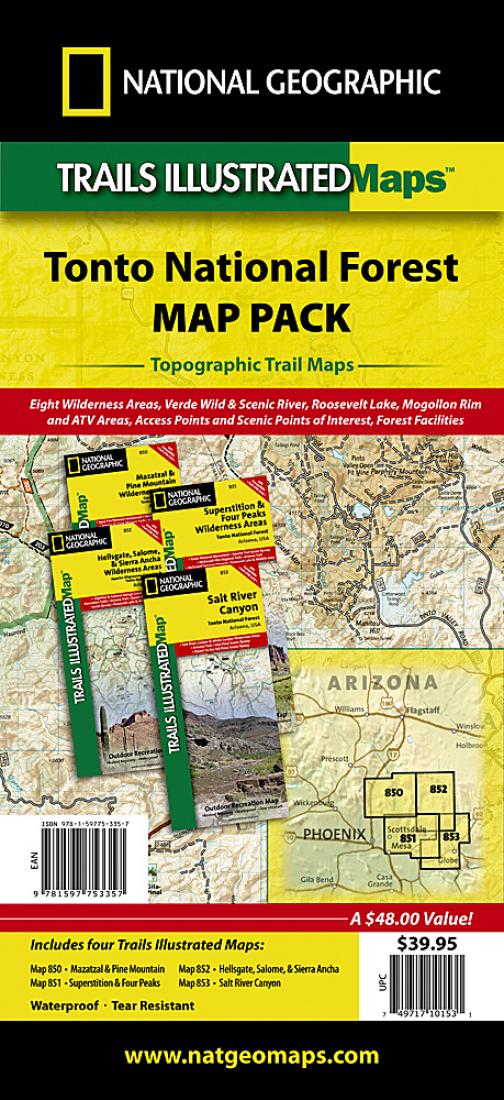
- Waterproof Tear-Resistant Topographic Map One of the most-visited urban forests in the U.S., with approximately 5.8 million visitors annually, the Tonto National Forest spans almost 3 million acres of diverse terrain just outside of Phoenix, AZ. Tonto encompasses a wide variety of vegetation ranging from cactus-studded desert to pine-forested mountains, and numerous recreational opportunities throughout the year. Each map contains easy to read trails, numbered forest service roads, campsites, access points, scenic points-of-interest, and important facilities. Some of the highlights of these four maps are: Mogollon Rim, Superstition Wilderness, Mazatzal Wilderness, Pine Mountain Wilderness, Four Peaks Wilderness, Hellgate Wilderness, Salome Wilderness, Sierra Ancha Wilderness, Salt River Canyon, Bartlett Lake, Horseshoe Lake, Saguaro Lake, Canyon Lake, Apache Lake, Roosevelt Lake, Verde River, Salt River, The Rolls and Bulldog Canyon ATV areas, and more. The Tonto National Forest Map Pack includes: Map 850:: Mazatzal and Pine Mountain Wilderness Areas [Coconino, Prescott, and Tonto National Forests] Map 851:: Superstition and Four Peaks Wilderness Areas [Tonto National Forest] Map 852:: Hellsgate, Salome, and Sierra Ancha Wilderness Areas [Apache-Sitgreaves, Coconino, and Tonto National Forests] Map 851:: Salt River Canyon [Tonto National Forest] Every Trails Illustrated map is printed on waterproof, tear-resistant paper. A full UTM grid is printed on the map to aid with GPS navigation. All proceeds from the purchase of a National Geographic map help support the Society's vital exploration, conservation, scientific research, and education programs. Contains maps (ML codes): 2034533M 2034535M 2034532M 2032664M
- Type: Folded Map
- Subtype: Park
- Language: English
- Publication Date: 2009-06-01
- Scale: 1:70,000
- Regions Covered: North America, Southwestern U.S.
- Countries Covered: United States
- States Covered: Arizona
- ISBN: 9781597753357
- MPN: TI01020511B
- Folded Size: 4.33" (W) x 9.45" (H)
- Unfolded Size: 37.2" (W) x 25.2" (H)
- Weight: 13.8 oz